Ever since hiking the AZT in 2023, I had wanted to hike thay Hayduke Trail. To be honest, I had some anxiety going into it, as it has a reputation of being pretty technical, super remote, and genuinely scary. I think the reputation is over-stated.
While the trail is not one that you can just showup to and hike, like the PCT or AT, it is nonetheless very hikeable! The main barrier to hiking is that you will need to setup at least 1 water cache.
Other than that, if you enjoy Type 2 fun, occasional bushwhacks, and some planning logistics, you’ll be good to go! I would strongly encourage hiking it with buddy! It’s good to have a second person to argue with about the correct route down or across some things.
Do I Really Need to Cache?
Although Mac (HalfwayAnywhere) says you do not need to cache on the Hayduke Trail, you really, really do. Unless, of coure, you want to deal with a 40-mile water carry in exposed desert heat.
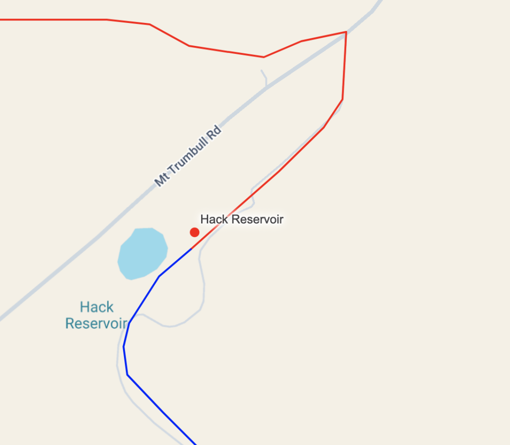
There is ONE place, in particular, that you will want to cache, that’s at Hack Reservoir on your way to the Colorado City resupply. Why do you need to cache here? Because the water before this point that would remove the need to cache is Willow Springs. This water is radioactive. So unless you really are okay with significantly increasing your likelihood of cancer, you will want to cache here. From the time Kanab Creek ends to the cache point at Hack Reservoir, it is around 18 miles. If you do not cache here, the next reliable water is Yellowstone Spring, which is 20 miles away, making a 38 mile water carry from Kanab Creek through a very hot, exposed section of trail. You’ll want to carry more than 2 gallons (8 Liters) of water if you’re not caching. You should be able to cache at Hack Canyon without needing a 4WD vehicle. Lower clearance vehicles would likely be fine across these roads as well.
Other than Hack Rservoir, the one place I cached at that I thought was meaningfully useful was off of Lockhart Road, around 38.33031, -109.67854. I contacted Bob Palin, who is a trail angel for the American Discovery Trail hikers, and he was willing to setup some caches near Moab for me.
The Lockhart Road cache can break up a longer water carry/bushwhack down to the Colorado River that I hear is quite unpleasant. Setting up the Lockhart Cache, however will require experience driving on pretty lousy trails that need a 4WD vehicle. So — probably not a rental car that you’d be in violation of the rental agreement for. I don’t think this cache is essential, but certainly was nice to have.
Near Hite it may be worth caching before the Red Benches. In 2025 and 2026, there were some reliable Cow Troughs that were well maintained with water, largely making a cache near Hite unnecessary. If those cow troughs are not there, you will need a cache (unless Hite Marina turns back on), or will need to hitch into town. It is likely a good idea to have a backup plan, as this is a dry, exposed section of trail, and the Red Benches are especially slow going. Jupiter recommends setting up a cache around 37.93681, -110.33578, which may be a good idea if you want to forego potentially hitching if the Cow Troughs don’t have water.
Finally, Grosvenor Arch has a solar well that has been known to be turned off/not operational, and can’t always be counted on. In 2026, the solar well was running. Prior to knowing the solar well was on, we decided to do a resupply and hitching plan from Grosvenor Arch into Tropic. The hitch into Tropic was fine — this seems very reliable. The hitch out of Tropic took a while, but also was fine. If you do not want to rely on the Hitch or yogiing water from folks in the area, it may be worth doing a food and water cache near Grosvenor Arch. I don’t think this cache is necessary, as you can hitch or likely get water from the road traffic if you need to. Apart from these 4 places to cache, I do not believe you need to consider other caches at this time, unless you want to.
| Cache name | Relative need to cache here | What kind of cache |
| Lockhart Road ~64 miles into hike (38.33031, -109.67854) | 3/5 – Breaks up a long water carry/reliance on a bad bushwhack, 2 miles off trail, down to the Colorado River | You only need water |
| Near Hite Marina ~155 miles into hike (37.93681, -110.33578) | 2/5 – It is useful to have water before you jump to the red benches. The water troughs off of Fortknocker Canyon road have been reliable in 2025 and 2026, making this cache less necessary. | You only need water, although food here could lighten the load, and wouldn’t be horrible to pick back up |
| Grosvenor Arch ~ 365 miles into hike (37.45447, -111.83346) | 2/5 – If you don’t plan to hitch into town, you should consider setting up a food and water cache here. The solar well has been off/on at different times. If it’s on, you’re good to go. | If caching, do water and food |
| Hack Reservoir ~ 724 miles into hike (36.61942, -112.84387) | 5/5 – Unless you want to do a 40 mile water carry in very exposed, hot conditions, you should cache here. | Water. Colorado city is only a 30-mile day away. |
Getting to and From Trail
Starting in Moab
Let’s face it, you’re hiking the Hayduke from East to West. I suppose you can go the other way if you want, although that seems less pleasant. You have two options, really:
- Fly into Moab Field Airport, and start walking from the airport (Great trail start. Super easy)
- Take a Train to Green River, then get a shuttle/hitch to Moab
If you don’t just start walking from the airport, you’ll need to get a hitch or a shuttle, in which case you can do the Devil’s Garden start. Which is definitely a nicer start, but harder logistically.
Ending in Zion
You’re likely ending your trip somewhere near Zion. It isn’t terribly hard to Hitch from the East Rim Road to Springdale. Springdale has a bus system, SunTran, that departs ~every hour from 7AM to 9PM. It’s $5 to travel from Springdale to St.George. Once in St. George, you can rent a car, take a shuttle to Las Vegas and fly back to wherever, or take a flight from St. George to a larger airport and then to wherever (likely more expensive)
A word of caution: If you end your trip on a weekend, the St. George shuttle to Las Vegas may have no space available, and they may have no rental cars. I would not recommend booking flights out of Las Vegas until you also have a St. George shuttle booked.
Other Towns worth Mentioning
There are a few other towns you might consider flying into/out of for different reasons
| Town | Getting Into/Out Of |
| Green River, UT | You can get into/out of Green River by Amtrak. Amtrak can take you to SLC where you can fly anywhere, or just directly take you somewhere. You can hitch Green River to Hanksville and the other way around pretty easily |
| Kanab, UT | You can hitch to Kanab from Highway 89. Getting back to Highway 89 from Kanab is harder, but not terrible. Kanab Airport connects to other larger airports. |
| Page, AZ | Good connecting airport. It’s likely not too difficult to hitch to Page from Highway 89. However, to get back to trail you will likely need to procure a shuttle. There are numerous shuttle companies operating in the area that will take you to/from Page. |
Resupplies and Hitchiking to Town (and the Colorado)
My general attitude is: resupply as often as possible to minimize the weight of what you’re carrying. On my Hayduke hike, I resupplied in Tropic twice. Once by hitching into Tropic from Grosvenor Arch, and another time by walking directly into Tropic as part of the longer Bryce Canyon Under the Rim Alt. Below is the list of town resupply options and access points
| Resupply Town | Access Point(s) | Notes |
| Moab | ~Mile 30: The trail walks directly through it | Town with all your needs. Full resupply opportunities are here. |
| Needles Outpost | ~Mile 90: You should deviate from the trail to walk directly to needles outpost. | You should send a package. There are limited quantities of gas-station quality food available to supplement a resupply. Some camping and showers available. [Your Name] c/o Needles Outpost US Hwy 211 Monticello, Utah 84535 |
| Hanksville | ~Mile 192 (Highway 95): You should hitch in | Market is okay — not an amazing selection, but good enough for resupplies if you’re not too picky. Hotel, camping, and a few restauraunt options available. |
| Boulder (But do not resupply here) | ~Mile 239 (Burr Trail in Capitol Reef): Hitch in | Likely a hard hitch back to trail. I wouldn’t recommend this as an option unless something goes wrong, or you have someone that can meet you/drop you back on trail |
| Escalante | ~Mile 300 (Hurricane Wash): Hitch in | The hitch is easier than expected. Full resupply options available. Town has several gear shops (with decent selection), and exceptional pizza. The town is a little too spread out to be a great trail town, but it would love to be. |
| Tropic and Cannonville | ~Mile 365 (Hitch in from Grosvenor Arch) and 414 (Walk-In) | Cannonville has a bakery. It’s worth hitting if you’re doing the walk to Tropic for the Bryce Alt. Tropic is an awesome trail town! It has everything you need, and is nicely packed together. The supermarket is great. The restaurants are perfectly adequate, and the people are nice! Bryce Pioneer Lodge will accept packages (UPS). The Lodge is a nice place to stay. The gas station/convenience store has hot food and okay resupply. The larger grocery store has more. |
| Kanab | ~Mile 464, Mile 510 (Hwy 89): Hitch in | You need to go a little bit down highway to the flatter area. You’ll get a ride, but may take a bit of time. hitching back you should hitch from the hardware store across from the BLM permit office. Town is spread out, but has everything. Multiple grocery stores and restaurants. Good place to zero. |
| Jacob Lake | ~Mile 510: Walk in | You need to send a box by UPS. You can supplement resupply with the convenience store, but the pickings may be slim depending on when you get there. I wouldn’t aim to do a full resupply out of this unless you fuck up. USPS can’t send here. They have food and rooms, but stuff is often not fully operating until main tourist season hits. Not a great place to spend a zero. [Your Name] C/O Jacob Lake Inn AZ-67 &, US-89A, Fredonia, AZ 86022 |
| Grand Canyon Village | ~Mile 620: Walk in | The store is pretty fully stocked. They also have a great gear selection. No need to send a box here. Yavapai Lodge can accept packages if you Amazon overnight something. If you need to send a box, there’s a post office in the village for USPS flat rate. |
| North Rim Lodge | ~Mile 640: Walk in | I hear you should send a box, or top-off from South Rim resupply. I didn’t stop here on my Hayduke. Everytime I go to GCNP, North Kaibab trail is closed so I have to find alternates around the closure. |
| Colorado City/Hilldale | ~Mile 758: Walk in | An absolutely awesome supermarket: bee’s. It has everything, including a salad bar! The town has a history of significant cult presence. The cult presence has mostly abated — only about 1% of folks appear to still be affiliated with FLDS. Folks are nice. The wealth disparity for different parts of the town is sad. Hardware Store, good thrift store — you can make stuff work here. South Zion Inn and Suites was a perfectly reasonable hotel to spend the night at. |
Hitchiking on remote dirt roads?
A lot of the hitching points, like to get to Escalante from Hole in the Rock Road feel pretty remote and out there. However, there are some major tourist destinations on these roads that get a fair bit of traffic, so you should expect to see quite a few trucks coming down. I was able to yogi some water and food in the parking lot from two different cars (coming in) at Hole in the Rock Road, and got a hitch out with the first car leaving (about 30 minutes later). It’s a long hitch out. It took 3 hitches from Escalante to get back to trail.
Similarly, we hitched from Grosvenor Arch into Tropic. In the morning, there were quite a few cars coming to Grosvenor Arch. We managed to get a hitch from Cottonwood Road — just past Grossvenor Arch — mid-morning. We hitched back to trail in the late afternoon, and had a harder time getting out of Cannonville. It would have likely gone better in the morning, but still only took a handful of hours of waiting to get back to trail.
How do I get a hitch across the Colorado River?
The main concern a lot of folks seem to have is “how do you hitch a ride across the Colorado River?” The reality is — it’s not that hard. You can get hitches in the morning. There are usually about 2-4 raft groups that will pass by a beach in the morning. Typically between the hours of 7:00 AM and 9:00 AM. After that, you’re unlikely to get a hitch until the following morning. When you see a boat, you’ll need to shout at them across the river “Hi! Can you ferry me across?!” Must rafters will oblige.
For the typical traverse going west-bound on the Hayduke, you’ll need to get to 61.1 mile camp and hitch downriver. The approach to 61.1 mile camp to get a hitch across the river is shockingly slow from the Nankoweap Granaries. I believe we ended up traveling at something close to 1-mile an hour, on average, through that section, so plan for an 8-hour journey to get form Nankoweap Granaries to the hitching point, which means you probably want to camp at 61.1 mile beach, or only a couple miles from it the evening before you plan to hitch across.
What if I’m going East Bound?
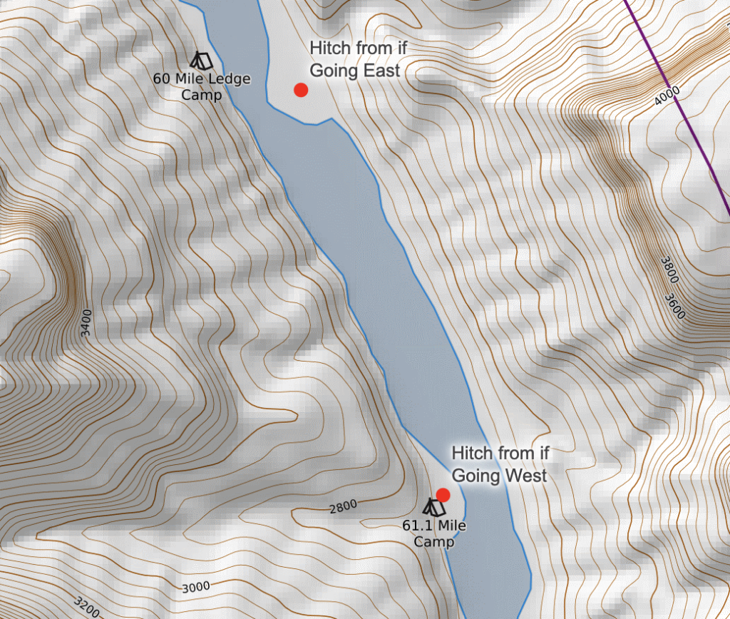
Yes, you can hitch across the Colorado River in the opposite direction. You’ll need to walk further up-river on the east bank of the Colorado, until you’re across from 60-mile Ledge, or have a good open beach for a raft to grab you. You can then hitch down river to 61.1-mile camp before backtracking north again to the Nankoweap Trail. If you’re going in the typical, east direction, Hitch from 61.1 Mile Camp to Old Fish Camp, about 2000 feet down river. DO NOT try to swim this. You’d likely get hypothermia and drown before you’d make it across.
Human Waste
You need a Wag Bag for Zion, Canyonlands, and Arches National Parks. You also need a wag bag for when you’re in Glen Canyon National Recreation Area. When In Grand Canyon, you can use the pit toilets, but are required to pack out waste from any designated camping area. For the entire trail, in general, you should aim to pack out all your toilet paper, as the sensitive desert ecosystems are not-too-likely to degrade it very quickly. I recommend using a backcountry bidet setup instead of toilet paper.
Permits
You do need permits for the trail! Grand Canyon and Capitol Reef are the main parks you’ll need to do permitting. The others largely won’t need permits as you can camp outside of park boundaries. Mac at halfwayanywhere has a much better, in-depth post on permits than what I will do, so just read that instead. I’ll highlight the two main permits to deal with below:
Grand Canyon
For GCNP, you’re going to get a permit to enter from Nankoweap Trailhead. I would actually encourage setting up two permits: one before South Rim. And one for after the South Rim, which will make it easier to adjust some dates, add some zeroes, etc.
Get this in the winter season, and make changes to it from trail. Send the backcountry office emails about a week in advance of the change you want to make. We tried to call them 30 times to make permit changes, and no one at the backcountry office answered the phone. Send them an email no less than 36 hours of your desired entry date.
Capitol Reef
They actually have a pretty great permit system. Contact the rangers, they’ll give you a little code type thing to cite if a ranger asks for the permit. Call up their backcountry office to talk to the rangers. In general, you will need to contact them to deal with acquiring a permit.
| Place With Permits | Advice on Permit Acquisition | Other Notes |
| Arches National Park | Rather than getting a permit, you can camp outside the park on BLM land. If you want to camp inside the park, contact the Moab Backcountry Permit Office via email or in-person. | Permits are limited to specific designated sites |
| Canyonlands National Park | Secure a permit for trails that are available from the Needles Visitor Center when you get there. You may need to change itinerary and plans. | If you take a shorter route through Canyonlands, you can backpack it in a day without camping inside the park. |
| Capitol Reef National Park | Email the park directly for a permit. The email system is easier than the old in-person requirement. | It is possible to avoid camping in the park entirely by pushing through in a single long day or camping just outside the boundary. |
| GSENM & Glen Canyon | You can self register at trailheads. For hayduke hiking, you do not need a permit | |
| Bryce Canyon National Park | You need to purchase and pickup at the visitor center. Because Bryce has right alongside park boundary, you can camp outside the park without a permit. | Camping inside the park means you will need a bear canister. |
| Grand Canyon National Park | Apply during the backcountry lottery windows in the winter. The Hayduke uses remote areas, making these permits slightly easier to obtain than the main corridor ones. | Each month’s application lottery should be registered about 4-5 months in advance. e.g. if you plan to enter the GC on an April permit date, you’ll need to enter the lottery in November. |
| Zion National Park | Walk-up permits are available 1 day before. Permits must be picked up in person. | If you go to Zion in advance of your Hayduke hike, you can become a “Zion Express Member“. If you do this, you can avoid going to the visitor center in person when entering the park for your permit. |
Gear and What to Bring
Important:
- Cord: You need to bring some cord. I pulled together 30 feet of 3mm dyneema cord for pack hauling, and to act as an emergency if I needed to support my weight through a makeshift harness (you almost certainly won’t need something with this kind of weight rating). There are numerous points where you will want to raise/lower your pack. You can often pass packs if you’re hiking with a buddy, but having the cord is worthwhile. You can get by with something lighter, but you’ll likely want 30 feet for Round Valley Draw.
- Water Capacity: I had a relatively mellow hiking season and had some good water caches setup, so never needed to carry beyond 5L. I took 8L of capacity, and am glad that I did. If temps had been hotter, I would have needed it.
- Backpack Capacity: Usually I hike with a 28L pack. For this trail, I found a 40L pack necessary to deal with the long food carries that coincided with long water carries (looking at you, Grand Canyon)
- Wag Bags: You need to have one for Canyonlands and Coyote Gulch. Most other areas you can duck out to BLM land. I never used mine.
Other than that, your usual gear should be fine! Here’s my gear list.
My Hiking List
My Trip and Report
I keep an email listserv that has various friends and other folks on it, that I send messages to every handful of days on town, with my writing and updates from the trail. Those posts can be found below.
My Slideshow and Photos from the Trail